Sunday 22 April 2012

Delft


In 1246, Delft received its city franchise from the Dutch Earl Willem II. As early as 1355 the city reached the size it would remain until the 19th century.

FIRES 
On the 3rd of May 1536 the great fire broke out. How it started exactly is not known, but it is likely that the wooden spire of the Nieuwe Kerk was hit by lightning and flying sparks set the surrounding houses on fire. Some 2,300 houses went up in flames. More than a hundred years later, in 1654, an explosion destroyed part of the city. The cellar of the former Poor Clares convent on Paardenmarkt was used to store gunpowder. This central warehouse for the region Holland contained some 80,000 pounds of gunpowder. The consequences of the explosion were enormous - two hundred houses were razed to the ground, and roofs fell in and windows were smashed in another three hundred houses. In 1660 a new gunpowder house was built about a mile outside the centre.

DUTCH EAST INDIA COMPANY
More than 400 years ago the Dutch East India Company was founded. It was one of the largest trading companies in the world with a fleet of more than one hundred ships, thousands of employees, offices in Asia and six sites in the Netherlands, of which one in Delft. In 1602, Delft was a flourishing city, a centre of painting, arts, crafts and science. The foundation of the Dutch East India Company and the establishment of a branch in Delft added another important aspect - the trade with faraway countries. Spices, coffee, tea and Chinese porcelain now found their way to the Republic of the Netherlands and to Delft.

KNOWLEDGE AND CULTURE
In 1842 the Netherlands lagged behind its neighbouring countries from an industrial point of view. The country required technically trained people, and therefore the Royal Academy for Civil Engineers was founded. The Academy used the building vacated by the artillery school. The Academy of then is the Technical University of today, which is also the largest employer in Delft. Some thirteen thousand students are registered with the TU in Delft. Delft is not just a city of culture, but also a city of knowledge. Not just because of the Technical University and TNO, but also because of the many knowledge-based institutes and companies - DSM Gist, the Dutch Normalisation Institute, the Dutch Measuring Institute, Exact Software, Delft Instruments etc. The Netherlands is world famous for its hydraulic engineering works. Students from all over the world come to the TU and the Unesco IHE to gain more knowledge. Large projects are simulated to scale in the WL/Hydraulics


Sunday 15 April 2012

Piazzale di Porta Romana - Florence


Porta Romana (Roman Gate) is the best preserved of the old gates of Florence (Firenze). It formed part of the southern walls around the city and through it passes the Via Romana which leads south to Rome. The gatehouse was built in 1326. In the arch above it, visible when heading south our of the city, is a 14th Florentine style fresco by Franciabigio called 'Madonna and Child and Four Saints'.

In the middle of Piazzale de Porta Romana, the large road junction just outside the gate, stands 'Dietrofront' by Michelangelo Pistoletto, an enormous statue of a woman heading south carrying something on her head.

The Piazzale is at the southern entrance to the Giardino di Bobou (Gardens of Bobou) which are associated with the nearby Palazzo Pitti (Pitti Palace), one of the top attractions in Florence. Also nearby is the Istituto d'Arte of Florence and Chiesa di San Pier Gattolino.


Sunday 8 April 2012

Checkpoint Charlie


Checkpoint Charlie, along with Glienicker Brücke (Glienicker Bridge) was the best known border-crossing of Cold War days. The sign, which became a symbol of the division of Cold War Berlin and read like a dire warning to those about to venture beyond the Wall – YOU ARE NOW LEAVING THE AMERICAN SECTOR – in English, Russian, French and German - stood here. It is today an iconic marker of territorial boundary and political division. Until the fall of the Berlin Wall on November 9, 1989, it signified the border between West and East, Capitalism and Communism, freedom and confinement.

The spot remains a must see sight in Berlin with huge historical and emotional resonance, even accounting for the fact that there is remarkably little left to recall the atmosphere of pre-1989 days. An enormous amount of debating went into deciding what should be left here and preserved for Berliners and visitors to see in the future.

Historically, the site is important because from 1961 to 1990 it functioned as the main entry and departing point for diplomats, journalists and non-German visitors who used to be allowed to enter East Berlin on a one day visa after exchanging their Deutsch Marks on a one-to-one basis for East German currency. More dramatically, US and Soviet tanks had a close encounter here in October 1961 when J.F. Kennedy and Nikita Khrushchev’s tanks faced each other in an acrimonious moment feared around the World as a possible lead up to World War III.

The wooden barrack where visitors to the Russian Sector (East Berlin) were once obliged to pass through for vetting was removed. Reconstruction has included a US Army guardhouse and a copy of the original border sign. The original white booth which served as the official gateway between East and West can be seen in the Allierten Museum in Berlin-Dahlem. Cobblestones mark the exact spot of the former border and the poignant photograph by Frank Thiel of an American and Soviet soldier can be seen here. Memorabilia includes the nearby Café Adler (eagle), a hotspot for journalists and spies in the past where informers met their counterparts.

The Museum, known as Haus am Checkpoint Charlie, contains the best documentation available on the many escape attempts from East to West. The original Checkpoint sign is exhibited here.

Ironically, the New Berlin has turned this area into an entry, rather than departure point, to a new kind of American sector. Today’s Friedrichstraße, with its Manhattan style office district, its new buildings by international architects such as Philip Johnson, who created the American Business Center, is the fruit of the millions in corporate investment which rebuilt this central part of East Berlin in the 1990s. 

Font:
http://www.berlin.de/orte/sehenswuerdigkeiten/checkpoint-charlie/index.en.php

Wednesday 4 April 2012

La Grand-Place - Brussels


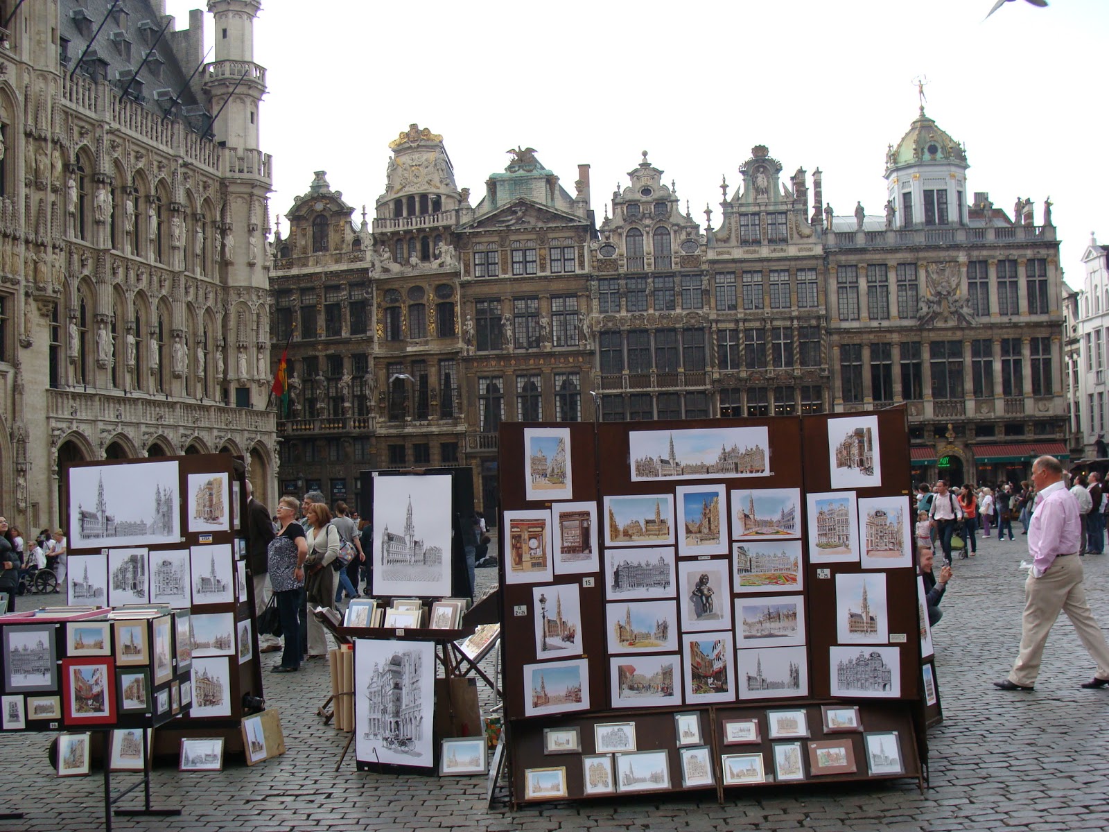
The Grand-Place is an outstanding example of the eclectic and highly successful blending of architectural and artistic styles that characterizes the culture and society of this region. Through the nature and quality of its architecture and of its outstanding quality as a public open space, it illustrates in an exceptional way the evolution and achievements of a highly successful mercantile city of northern Europe at the height of its prosperity.
The earliest written reference to the Nedermarckt (Lower Market), as it was originally known, dates from 1174. The present name came into use in the last quarter of the 18th century.
It is located on former marshland on the right bank of the River Senne, to the east of the castellum, a defensive outwork of the castle built around 977 by Charles of France, Duke of Lower Lotharingia. The marsh was drained in the 12th century. The present rectangular outline of the Grand'Place has developed over the centuries as a result of successive enlargements and other modifications, and did not take up its definitive form until after 1695. It has, however, always had seven streets running into it. In the 13th and 14th centuries the market-place was surrounded by haphazardly disposed steenen (the stone-built Cloth, Bread, and Meat Halls or Markets) and timber-framed houses, separated by yards, gardens, or ambiti (passages serving as fire-breaks). During the 15th century the houses on the south side were replaced by the east and west wings of the City Hall (1401-44) and its bell tower (1449). A new Bread Hall was built on the north side in 1405.
The Bread Hall was demolished in 1512-13 and replaced by a large building that was given the name 'the King's House' (La Maison du Roi). During the course of the 16th century many of the houses were rebuilt with new facades in Renaissance or Baroque style. On 14 August 1695 Louis XIV of France ordered Marshal Villeroy to bombard the city as a reprisal following the destruction of French coastal towns and ports by Dutch and English warships. Despite the severity of the bombardment, reconstruction was rapid, thanks to the action taken by the City authorities and the generous support of other towns and provinces. In a remarkable ordinance promulgated in 1697 by the City Magistrate, all proposals for the reconstruction of facades had to be submitted to the authorities for approval, so as to preserve the harmony of the square. In four years the Grand-Place had been completely restored to its original layout and appearance..
The Hôtel de Ville (City Hall), which covers most of the south side of the Grand'Place, consists of a group of buildings around a rectangular internal courtyard. The part facing on to the square is from the 15th century, consisting of two L-shaped buildings. The entire facade is decorated with statues dating from the 19th century. The southern part of the complex is a restrained classical building that closes the U-shaped plan of the Gothic structures, built in the 18th century. Facing the City Hall across the square is its other main feature, the Maison du Roi (King's House), now used as the City Museum. In 1873 the City Council decided that its state of conservation was so bad that it should be demolished and rebuilt. The reconstruction was based on the original. The result is a three-storey brick building with an arcaded facade, saddleback roof and centrally placed tower with lantern.
Each of the houses around the Grand'Place, which vary considerably in size, has its own name: Les Ducs de Brabant, Le Roi de l'Espagne, Le Cornet, Le Cygne, the Maison des Brasseurs, Le Cerf, La Maison des Tailleurs. The degree of conservation of original features inside the houses around the Grand'Place is somewhat variable. In some cases almost no changes have been made since the early 18th century, whereas in others there has been radical conversion and modernization. In a number of cases the ground floors have been converted for use as shops, restaurants, or cafes.

Sunday 1 April 2012

Neumarkt


The Neumarkt (New Market), probably the best-known square in Dresden's downtown, is being reconstructed gradually, following its former opulent Baroque design. The goal of the new buildings is to recreate the historic structures.
The Neumarkt area has only been part of Dresden since 1548. The square developed its structure and its particular charm during the Renaissance, characterized by the typical gabled houses. With its continuing construction during the early Baroque period, the Neumarkt matured into a completed work of art. The Seven Years' War from 1756 to 1763 seriously damaged the area. The square was later rebuilt in a simpler late-Baroque style. With the construction of the Frauenkirche in 1726 -1743, by George Baehr, the area came together more strongly and created a symbolic whole for the first time.
In subsequent years the square changed very little, but it did bear witness to numerous political conflicts, such as the revolutionary street battles in May 1849 and the destructive attacks of World War II. The ruins of the Frauenkirche and its surrounding area remained untouched for many years, acting as a memorial.
The dedication of the Frauenkirche on October 30, 2005 breathed new life into the Neumarkt. Since then, numerous historic quarters have been renovated, combining elements of the traditional and the modern. The stately houses, with their faithful recreations of the original façades, lend historic flair and create an inviting strolling, shopping and dining experience.